
Date: Postponed
Time: 10pm ~ 2+am
~ end-time also depends on how many kopi breaks and holan we make :lol:
Objective
This is a late night "At Worlds End" round Singapore island tour... plan is to ride clockwise and visit corners of the island which we seldom or hardly will go; also for running in a new bike.
This is a late night "At Worlds End" round Singapore island tour... plan is to ride clockwise and visit corners of the island which we seldom or hardly will go; also for running in a new bike.
Participants:
1. scoobydoo
2. sant0s
3.
4.
1. scoobydoo
2. sant0s
3.
4.
Distance & Time
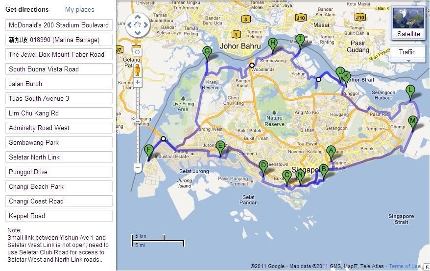
According to Google Maps, total distance is about 169km, requiring about 4¼hrs.
The small "trunk road" link between Yishun Ave 1 and Seletar West Link is not open. Thus we'll need to ride south on Seletar Club Road for access to Seletar West Link which joins to Seletar North Link on the 2 Punggol Islands.
Finally got the route together. We're invading Seletar North Link!!! It's a new route that links Yishun to Punggol, the road is built up but it's not totally opened to car traffic yet. So, we can almost have the whole place to ourselves.
Itinerary
* Meet at 10pm: Kallang McDonalds
* ECP - Marina Barrage
* ECP - Keppel - Mt Faber
* Pasir Panjang - 9弯18拐 (to-n-fro, U-turn at NUH)
* West Coast Highway - Jalan Buroh/Pandan Reservoir
* Jln Ahmad Ibrahim - Tuas West/South (till the end facing Johor)
* Jln Ahmad Ibrahim - PIE - Jln Bahar - Lim Chu Kang Rd end (till jetty)
* Lim Chu Kang - Kranji Way - Woodlands
* Stopover/Break @Woodlands 24hrs Al-Ameen ... lets freshen up
* Admiralty Road West/East - Sembawang Park
* Yishun - Yishun Ave 1 (cross Lower Seletar reservoir)
* Punggol Islands
* TPE - Pasir Ris Park
* Loyang Ave
* Changi Beach Park (facing tekong)
* Changi Coast Road - ECP - Keppel Rd
* ETA 2am End/Supper: Outram Park 亚华肉骨茶
* OTOT Home-Sweet-Home
Kallang McDonald's (Stadium Boulevard)
Location Map
Al-Ameen Eating House (Woodland Outlet)
Location Map
Outram Park 亚华肉骨茶
Located at Keppel Road (Tg Pagar Complex) and opens till 4am... end point, makan then disperse.
Location Map
Review
Related YouTube clip:
Seletar North Link
No comments:
Post a Comment